
 The Dakota 20 is a navigation device that came onto the market in mid-August 2009. This handheld is aimed primarily at hiking, trekking and mountaineering as well as geocaching and mountain biking. Compared with the Oregon range, what stands out is that the Dakota is a good deal smaller and lighter. Can it keep up with its big siblings in this format?
The hardware and design of the Garmin Dakota 20
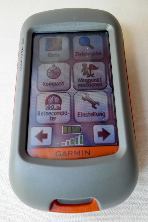
 On this compact GPS handheld, operation is almost entirely via the 2.6-inch (6.6 cm) touchscreen with a resolution of 160 x 240 pixels. As is usual with a car sat nav, almost all menu items and functions are called up through this small touch-sensitive screen. Anyone who has used a Garmin from the Oregon range will find their way around the Dakota immediately. Apart from the touchscreen, the unit can only be operated with a single button on the right-hand side. That button has just these functions: on/off, adjust the backlight, lock the screen.
The Dakota can be used in the rain too
The Dakota needs two AA rechargeable or disposable batteries. Battery life is quoted at 20 hours . The battery compartment is on the back of the unit. The microSD card slot sits underneath the batteries. Behind a grey plastic cover above the battery compartment there is a mini-USB port. According to Garmin the cover, like the rest of the unit, is protected against water ingress. The Dakota is accordingly classified as waterproof to IPX7.
 Maps suitable for hiking are not included with the Dakota
Among other things, the unit has a barometric altimeter and, worth singling out, an electronic three-axis compass. It shows the direction accurately even when the unit is moved and not held completely level. Maps that would be usable for hiking are NOT supplied with the Garmin Dakota 20. These TOPO maps have to be bought separately.
Technical data of the Garmin Dakota 20
(extract from www.Garmin.com)
- Unit dimensions, W x H x D: 5.5 x 10 x 3.3 cm (2.2 x 3.9 x 1.3 in)
- Display size, W x H: 3.6 x 5.5 cm, 2.6-inch diagonal (6.6 cm)
- Display resolution, W x H: 160 x 240 pixels
- Display type: Transflective colour TFT touchscreen
- Weight: 191.4 g with batteries
- Battery: 2 AA batteries; NiMH or lithium recommended
- Battery life: 20 hours
- Waterproof: yes (IPX7)
- Floats: no
- PC interface: USB
- Built-in memory: 850 MB
- Accepts memory cards: microSD™ card
- Waypoints: 1000
- Routes: 50
- Track log: 10,000 points, 200 saved tracks
- Electronic compass: tilt-compensated, 3-axis
- Barometric altimeter: ja
- Geocaching mode: Yes (paperless)
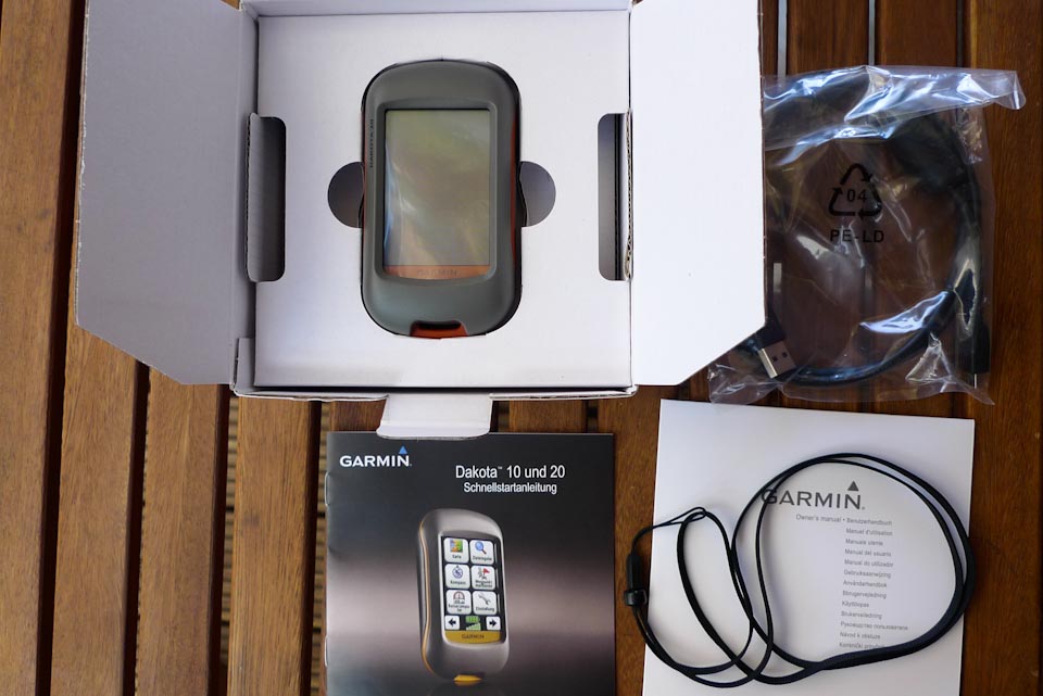
What is in the box with the Garmin Dakota 20
- Garmin Dakota 20
- Wrist strap
- USB cable
- User manual on CD
- Quick start guide
Testing the Dakota 20 in practice
A note first: to do anything useful with the Dakota at all, the topographic map or maps for the region have to be installed before the first walk. Garmin offers these in good, comprehensive quality. They are not exactly cheap, though.
Beyond that there are free alternatives too, some of comparable quality, although they are not yet available for every region (www.openstreetmap.org). For this test the Dakota was fitted with Garmin TOPO V2 Deutschland. The new version Garmin TOPO V3 that is currently available differs hardly at all in content from the version used for the test.
The Dakota is almost a small Oregon
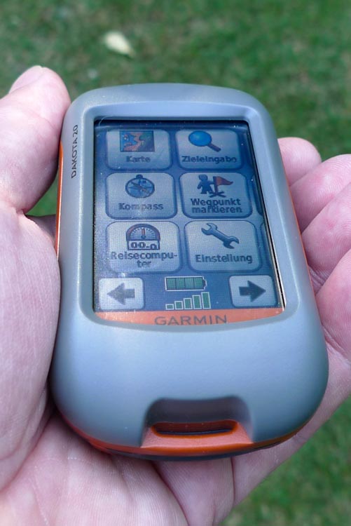
If you have ever held a device from the Oregon range, the first thing you notice about the Dakota is of course its pleasing size. The unit sits very well in the hand and the case makes a solid impression. The power button on the right-hand side of the unit is relatively small and a little stiff.
The menus, operated exclusively by touchscreen, are mostly laid out logically and are easy to follow. There are a few points that could certainly have been arranged more clearly and logically, and the translation of the menu items still leaves something to be desired in places. All the functions you need for hiking and trekking are there, though, and easy to set.
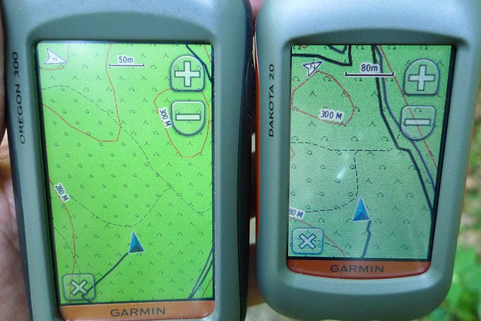
- Display comparison: Garmin Oregon and Dakota
Now to the display of the Dakota — and with it straight to the most critical point of this small outdoor navigator from Garmin. Anyone who knows the eTrex range or the Garmin GPSMAP 60CSx will rub their eyes at the first sight of this display and go looking for the function to turn up the brightness. Unfortunately you quickly discover that it is already at maximum. Even in rooms with weak lighting you notice that the menus are quite dark. In principle you can make everything out and read it, but a brilliant, high-contrast display this is not.
Once you take the Dakota outside you find that the backlight effectively has no function any more. Depending on the viewing angle and the position of the sun, the display can be read more or less well, or not at all. While hiking this is not so much of a problem because you can quickly change the angle of the Dakota relative to the sun. It is irritating all the same, especially if you are used to a better picture from older devices. Fundamentally, though, it has to be said that at the current state of the art a touchscreen probably cannot achieve the crispness that would be possible without the touch layer.
The Dakota display does not have a good resolution
 The size of the display is in principle sufficient. However, the resolution of the display is not particularly good either (also compared with Garmin’s Oregon range). The result is that the map information visible at any one time is relatively limited.
The map view has to be panned fairly often if you want a little overview of the area around your current position. Simply changing the map view with the zoom function usually does not help, because many details are then no longer visible.
Now to the reception quality of the Garmin Dakota. After a few kilometres in more and less difficult terrain, the Dakota can be credited with good to very good performance. Even in dense deciduous woodland the little navigator never lost satellite reception completely. The tracks — the recordings of the tours — were relatively accurate apart from small outliers. It did happen that the Dakota was a little “off” a few times, but for hiking these deviations of a few metres are almost always completely unproblematic. Only in exceptional cases, on tricky mountain tours for example, might this cause some head-scratching.
 The new three-axis compass still causes trouble now and then
The new three-axis compass, which reliably points the way even when the unit is not held completely level, is a big step forward compared with the “older” Garmin devices. To be able to use it really reliably in difficult terrain, though, the unit unfortunately lacks a sighting device. Only with one of those can the direction shown be transferred reliably onto the terrain. So in the end it remains a rough aid to navigation. During the test, incidentally, the compass occasionally went into uncontrolled continuous rotation, which could only be fixed by recalibrating or sometimes by restarting the unit. This is probably “only” a software bug that Garmin can fix with a firmware revision.
The good battery life is sufficient even for long walks
Battery life is quoted at 20 hours. With appropriate use of the power-saving functions in the menu, even longer run times can be achieved while hiking. The condition for that is that you do not constantly wake the display to look at the map when it has just gone into standby. Battery life is therefore absolutely sufficient for use on day walks. On longer trekking tours you will of course have to think about how to resupply with power along the way.
Verdict: The Garmin Dakota 20, a handy, light navigator for hiking
The size and weight of the Dakota are a delight and the reception characteristics are good too. All the important functions for hiking are there and, given the extensive feature set, operation is well solved. The rendering of the maps and menus and the resolution of the display, however, are satisfactory at best.
If you place great value on a light navigator (ultralight hiking and trekking) and can live with the small display, the Dakota is worth considering for its positive qualities. Otherwise it is also worth taking a look at the proven Garmin Oregon 300 / 400t . The price of the Dakota is still relatively high at the moment (around EUR 320), as the unit has only recently come onto the market. Relative to the competition — and in particular Garmin’s own — a street price of around EUR 250 can probably be expected before long.
UPDATE, January 2010: The forecast we gave on prices has come true. The price of the Garmin Dakota 20 is currently around EUR 240 (as of 01/2010 — see the Amazon links at the end of this article). Several firmware updates have added new functions. Custom maps of your own can now even be displayed on the Dakota 20 Dakota 20 firmware update
Pros:
- Weight and size
- Battery life
- Three-axis compass
Cons:
- Display resolution and brightness
- (for now) comparatively high price